
A first step in trying to understand and document what occurred between July 12th and July 23rd in the Meuse river basin.
This was an exceptional weather event. However it was correctly predicted.
In Germany in the Eifel region (mainly tributaries to the Rhine) they had 3 months of rainfall in 36 hours and in Belgium in the Ardennes (tributaries to the Meuse river) they had 2 months of rainfall in 24 hours. People had been warned in most cases. Both the emergency services and the public clearly underestimated the consequences. There was no clear messaging.
Messaging should be timely, specific, in the language people speak, and should be understandable. People have to be able to relate to previous events to understand the predicted event, to be able to take the proper measures so stay safe.
Institutional changes are often needed after a flood. Especially when the time needed for a flood alert and a proper response is extremely short. In the Netherlands, the tidal hydrologists were merged with the meteorologists in the same organisation after the 1953 flood (for storm surges). The Czech Republic has set up centres where the emergency services were added to a team of hydrologists and meteorologists to cope with flash floods since the 2003 flood event.
Most of the damage in the Netherlands is from overland flow/flash floods from streams in valleys. In Germany and Belgium, this was also the case.
Institutional errors were made in the messaging to the public, in the construction and operation of reservoirs and probably in spatial planning. The Netherlands has very clear spatial planning rules for major rivers, but is rather bad at the enforcement of these rules. The Netherlands can learn a lot from Belgium, where they have recently enforced spatial planning rules in flood prone areas vigorously.
In the Netherlands at the gauging station Sint Pieter (near Maastricht), at km 10 on the Meuse River in the Netherlands a discharge of 3260 m3/s was measured. This is the highest discharge measured since the start of formal measurements in 1911. Other high is discharges this century all occurred in the winter: December 22nd of 1993, 3120 m3/s. January 1st 1926 ~3000 m3/s and January 1995 2870 m3/s.
The previous highest summer discharge was about 1000 m3/s in 1980.
In the Netherlands in one town, Valkenburg the direct damage is about 200 million euros and the indirect damage is about the same amount. In Germany and Belgium, damages are a lot higher. The damages to the railway systems is already above one billion euro’s.
This extreme discharge on the Meuse River has a return period of about 100 years (for the winter statistics) at km 10 Borgharen[1]. However, this was a summer discharge. Rijkswaterstaat, KNMI and Deltares are, currently investigating what the relationship is between climate change and this flood event.
The flood wave was exceptionally short and high. This means that the water levels downstream corresponded with return periods of 25 years (Venlo, km 108) and 10 years at Gennep (km 155)
The measures of the large project the Meuse Works were largely effective. The Meuse Works was a complex project. It was a mixture of sand and gravel mining project including landscaping afterwards, room for the river measures and heightening and strengthening of dikes constructed hastily in 1995 and 1996.
The dikes constructed in 1995 and 1996 after the floods of 1993 and 1995 removed 40 % of the flood plain from the river. Some of these dikes have been built perpendicular to the flow of the river. So these dikes obstruct the flow of the river.
This means that at some locations especially at Maastricht the observed river levels were a lot higher than in 1993, while the recent discharge in 2021 was only about 100 m3/s higher (an effect of less than 10cm). At other locations, the increased river flow was also influenced by changes in the relationship between the tributaries in the Netherlands and the main river. In the Meuse Valley the Netherlands seem to be protecting a lot of pasture and seem to forget the cities and the national infrastructure (highways and railways).
The Water Management Centre for the Netherlands (WMCN) correctly predicted the water levels in the Meuse River, both the expected water levels and the time of the peak discharge at each spot of the river. There were 21 bulletins, during the peak discharge three to four (if a correction was needed) per day. Some figures were manually adjusted because of backflow due to flow from the tributaries, also some recent room for the river measures were not included in the model and due to weirs which were being refurbished and could not be completely opened. Instead of waiting for corrected data, the regional water authority in Limburg carried out their own predictions, which were more erroneous than those from Rijkswaterstaat (especially in the timing of the peak). These alternative “facts” also caused confusion within the teams responsible for crisis management.
Normally new models go on line on or before October 1st the start of the winter season. The new model (not yet online) is currently being tested at Deltares has already been corrected for the room for the river measures and can use real data for the flow from tributaries (instead of statistical relations).
The national committee on floods provides information on the impact of the flooding. The national government and the water boards provide the input for this information.
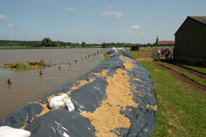
The regional water authority in Limburg[2] and Rijkswaterstaat were heavily involved in the flood fighting. Rijkswaterstaat had to sandbag a spot on a canal dike which had flooded a village (Meersen). The local population also initiated a number of measures. Sandbags were often placed where dike had not been reinforced yet to comply with the new standards, to combat piping and probably also slope stability or to reinforce mobile flood barriers (against uplift). Some people built their own dikes to protect their houses in the flood plain (e.a. at Horn for ten houses). There the temporary dike made up of not compacted top soil and plastic foil failed. The municipality had helped. The regional water authority was not involved. None of the sandbags had an influence on the water levels downstream in the provinces of North-Brabant (with the city of ‘s Hertogenbosch) and Gelderland where you have the largest population densities. This was also due to the very short discharge wave, less than a week.
Other regional water authorities and Rijkswaterstaat personnel assisted in the Limburg. The request for assistance was done through the union of water boards / union of regional water authorities (https://www.uvw.nl/). All assistance was coordinated through STOWA (from their vacation locations abroad).
The national committee on floods (LCO) also provided personnel from the Crisis Team for Flood Defences. The men and women from the military were very effective in sand bagging an eroded weir maintained by Rijskwaterstaat and in sandbagging a number of dikes for the regional water authority. After the floods they have started removing fallen trees from the tributaries to the Meuse.
Every flood wave on a river causes damages both above the water line and below the water line. Some of the damage has been tackled through emergency measures as sandbags. The winter season will start within two and half months. This means all dikes, structures and the riverbed have to be inspected and the most important damages have to be repaired before October 1st 2021. Some of the damages occurred to structures where we knew there was an issue for over twenty years.
One example is the sluice gate of the “Zuid Willemsvaart” a 19th century structure. This set of gates is too low. More than 2 meters of water overtopped the gates.
This canal is directly connected to the Albert Canal in Belgium. There is no flood risk in the Netherlands, which is why this problem had not yet been tackled. However houses in Genk (50 km away) in Belgium along the canal were flooded due to increased discharges from Belgium and the Netherland to the canal. Our water systems do not stop at the border. Closer cooperation is needed.
The Meuse river and the tributaries reacted differently to the extreme rainfall event than we expected. This means we need to look into flood risk for the whole river system including the tributaries. Cooperation with Belgium and Germany is advised. For the Netherlands this means we have to look at the main river from Eijsden (km 0) until Keizersveer (km 250) and we should not forget cross border flooding.
This flood is a good warning for everyone who has built in the flood plain since 1995. There are more than 2500 houses now when in 1995 there were only a few hundred. People are not protected and by law should not get their damages reinbursed from the disaster fund if the house was built after 1995.
Since 2017 all flood defences are allowed to fail at a certain agreed level. For each and every flood defence this protection level has been described in the water act (in the last update from 2014), see the Fundementals on Flood Defences[3]. This means that a number of the measures prepared since 2010 for the Meuse river, the “systeem maatregelen” no longer seem fit for purpose. These measures were devised as a compensation for the fact that formally the 45 former “dike rings” / dike systems along the Meuse will no longer be considered part of the flood plain. As mentioned before this removes 40% of the flood plain from the river and endangers cities like Maastricht. The Netherlands seem to want give pastures almost the same level as protection as neighbouring cities. The former provincial government (2 years ago) wanted to correct this. The current provincial government seems not to want any changes.
Due to climate change, a larger part of the valley will become flood prone. A 6000 m3/s means about 60 km2 should be included in the formal flood plain. Floods in this area also protect the cities downstream by lowering the design water levels by about 30 cm. This will require new spatial planning measures, since the population has to be informed of this flood risk.
Two years ago the province of Limburg has drafted a good plan to tackle this issue by removing or lowering the status of 22 of 45 dikes systems along the river. This means the province focusses on the cities and towns along the river, which need extra protection. It is easier and more acceptable to evacuate a village of 1000 people than a city of 20 000. The population who live along the river initiated these plans, they prefer a good view, and a few scares, and maybe a flood than huge dikes in front of their houses. This situation is different from Amsterdam (Durgerdam) where a few hundred people do not want to reinforce a dike (because it is next to their house) but the dike protects more than half a million people.
The Delta commissioner in his response to the plans by the province does not seem to understand that the cities of Maastricht and ‘s-Hertogenbosch are at stake, including the national infrastructure (highways and railroads). If the Meuse valley is to remain liveable and climate proof urban developments should be planned in the main cities and towns and not in the flood plain which is still largely empty.
The problems in the tributaries to the Meuse River have been neglected for a long time. Every ten to twenty years there is a flood event. People get used to it, but the impact of these flood events will increase over time and due to climate change. At a certain point people, start dying in large numbers, as we can see in Belgium and Germany. E.g. people expected a larger discharge with water levels about 3 meters higher than normal, not 7 meters. Planners have to think through the worst credible floods. An event with a return period of 1000 years is not un-imaginable. You have to know if the event is deadly or not before you allow a new urban development or even the construction of one single house, which is not adapted for a flood event.
Another reason why the impact of the floods were higher may be the construction of reservoirs for rainfall events with return periods of 10 and 25 years in the tributaries to the Meuse River in the Netherlands. When there is a rainfall event the managers of the water systems should – discharge – the hold on to the water in fields, then use reservoirs and then again discharge. In this way the tributaries react naturally to the high precipitation event and they discharge into the main river the Meuse before the peak flows have reached from the Ardennes in Belgium[4].
As a researcher, a large flood event is also an event to learn from:
- What is the impact of climate change? If we cool the climate by two degrees in our climate model for the data of week of July 15th (1 degree more than the current change in temperature), will the same precipitation event be seen?
- Understanding why this precipitation caused this particular flood wave.
- Looking into the precipitation events just weeks before and after the event,
- Can we see a pattern?
- Were the systems and the soil full or empty?
- Was this the worst case, if we move the precipitation event 50 km to the west, to coincide with a larger part of the Meuse basin, what will happen?
- Understanding how the flow wave moves through the river
- This was an event with a short duration, the upstream areas in the Netherlands and Belgium were hit the worst, in the downstream areas the discharge wave was uneventful
- Why do datasets for the same model of the river, provides such immense differences in design wate levels (sometimes almost a meter), is this the effect of the discharge wave and the relationship with the tributaries?
- Should we consider both the height and width of discharge waves in the probabilistic modelling for determining hydraulic boundary conditions?
- Understanding the relationship between the tributaries and the river
- Due we understand the relationship for each tributary,
- Was this the worst case?
- How can we modify the relationship to reduce damages? Is this wise with expected climate change?
- What happened below the water level
- Was there a large bed flow
- Where can we observe sedimention and erosion
- Do we understand why this happened
- Is this a reason to worry,
- Are control structures in danger due to erosion or debris?
- Are flood defences in danger due to erosion (deep scour holes can destabilise a dike)
- Are flood defences in danger due to sedimentation and debris, because of higher water levels
- Where do we see damage to structures and flood defences, can we explain the reason they were damaged?.
- Is damage only due to overtopping, e.g. for a weir
- Where was piping and seepage observed ?
- In 2007-20014 chocking points on the river were modelled, did they occur, or was the flood wave too low at these sites?
- Looking into the precipitation events just weeks before and after the event,
[1][1] The Meuse rivier starts at kilometer 0 on the border at Eijsden in the Netherlands, this is about at km 700 if you start counting at the source in France on the Langres Plateau. the nuber stop at about 60 km before the sea in the Amer, the Rhine/Meuse Estuary.
[2] https://www.waterschaplimburg.nl/
[3] https://www.enwinfo.nl/publish/pages/183541/grondslagenen-lowresspread3-v_3.pdf
[4] Actualisatie beschrijving laterale toestroming Maas, Rolf van der Veen, 2018 and Van regen tot Maas. Grensoverschrijdend waterbeheer in droge en natte tijden’ Marcel de Wit, Uitgeverij Veen Magazines (ISBN 978-90-8571-230-5).
Recent Comments